Project Snapshot
The landholders purchased the pastoral lease in October 2019 to complement their neighbouring station.
Post settlement, the landholder started considering ways to reduce the grazing pressure from both domestic stock and feral herbivores in vulnerable parts of the property to allow the land to recover. With the drought conditions being experienced at the time, the first action undertaken was to remove feral cattle, horses, and camels.
However, the challenge of balancing economic returns from running a viable pastoral operation, and delivering important large-scale recovery plans for the land and vegetation led the landholders to look for alternative income streams.
Carbon markets offered an economic diversification pathway that would allow the integration of both pastoral activities and regeneration-focused practices into a dual operational model for the landholder. Carbon markets present opportunities for pastoralists, with new revenue derived from increasing carbon sequestration in the HIR specific vegetation. Carbon credits (ACCUs) generated on the station were pre-sold. The proceeds were used to contribute to the management costs and invest in resources needed to achieve the overall aims of the HIR management plan.
RegenCo first undertook a pre-feasibility analysis of the station to identify areas that had the potential to regenerate, and that were not forest in the preceding 10 years to 2021. The Human Induced Regeneration project was registered conditionally on 14th December 2022 and unconditionally on 23rd September 2024.
Overview
Geography
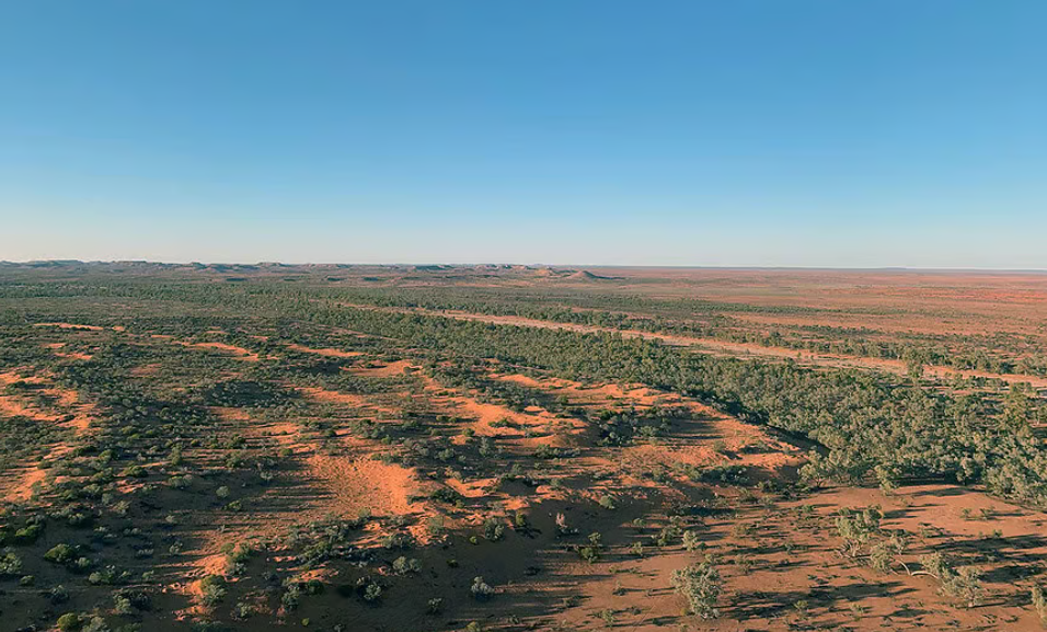
The station has a total area (under Perpetual Pastoral Lease) of 4628 km² in the Northern Territory. The property is located in the Finke River catchment, south of Alice Springs, with the Ghan Railway passing through the middle of the station.
Key Features
A 2018 report, produced by the NT Department of Environment and Natural Resources, on the Station’s land condition, found that it was generally assessed to be in Fair to Poor condition.
The pastoral station has grasses and important pasture species; several land systems on the station also support areas of open woodland and shrubland. The more palatable canopy species in these systems, such as mulga, have been overgrazed by cattle and feral animals when rainfall was low and grass in short supply.
It was considered highly likely that vegetation conditions would continue to decline if grazing pressure was maintained. Upon purchase of the pastoral lease in October 2019, the landholders immediately looked for the most viable business solutions to the challenges posed by overgrazing.
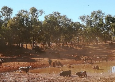
Wild horses and cows at a dam on the station - taken in 2018.
Project Activity
The landholders partnered with RegenCo to implement a vegetation carbon project and to consider mitigating the native forest regeneration suppression factors. Once the registration of the 25 year HIR project was achieved, RegenCo created a HIR management plan, a Permanence Plan, a Grazing Management Plan and an Activity plan, in collaboration with the landholders, after extensive visits to the property.
In 2023, RegenCo, together with the landholders, devised a HIR management plan outlining practice changes that initiated and maintained native forest regeneration in areas subject to historical grazing suppression. The plan allowed for protection of tree regrowth to ensure permanence obligations, whilst taking into consideration the continuation of the cattle business.
These management activities included:
- Managing the timing and the extent, of grazing
- The humane management of feral animals
- Control of weeds or plants that are not native to the project area
- Management of hydrological processes to manage erosion and enable increased regeneration
- Management of risk of wildfire to ensure regenerating land condition and forest are not disturbed or reversed
The property then underwent field survey, drone LiDAR survey of the field sites and fence line to fence line aerial LiDAR capture, enabling the creation of a Digital Twin of the pastoral lease.
Broad Practice Changes
Introducing revised cattle management strategies to support the specific goals of species regeneration is the overarching business objective to which all decisions are anchored, with a focus on proactive management.
- The inclusion of digital imagery to consider ecological, hydrological, and geographical factors allows the landholder to determine both effective and efficient practices to complement pastoral and carbon project goals separately. For example, the efficiency of existing water points was assessed, leading to the adjustment of infrastructure such as fencelines or waterpoint placement. These changes ensure that grazing areas are maximised for cattle while also minimising grazing pressure on regenerating carbon areas.
- A Grazing Management Plan was created to reduce the risk of cattle overgrazing grasses, leading to the browsing on regenerating HIR tree species. Most HIR species are secondary browse, meaning they are not the primary forage choice for cattle, which generally prefer grasses and other palatable plants in the landscape. The plan focuses on strategic grazing management, including seasonal adjustments of cattle numbers around water points and resting carbon regeneration areas from grazing during critical growth periods. For example, the landholder’s mustering frequency increased to reduce cattle numbers in a more proactive manner.
- A Permanence Plan was created to assess the risk of removal and destruction of regenerating carbon species. The highest risk is the spread of wildfires caused by lightning strikes or accidental ignition from bordering roadways & railway. The landholders increased the number and width of fire breaks around the station.
- An Activity Plan brings all the above strategic tools into a 6-12 monthly summary of the activities the landholder will undertake to meet the goals of the combined cattle and carbon business.
Technology & methodology
RegenCo’s Data-Driven Approach
RegenCo uses a combined airborne-LiDAR and satellite spectral mapping approach. We are the first HIR project in Australia to do so for the whole property.
LiDAR data captures precision tree and sapling height and width information – which is essential for understanding where mature and regenerating trees are – while spectral data helps identify tree species.
Finally, detailed ground surveys are conducted.
These data and our mapping methods allow us to identify regeneration with precision, and allow our landholder to balance environmental and economic outcomes with sensible management.
- Field surveys were conducted across September-October 2023
- Drone LiDAR was collected in December 2023,
- Aerial LiDAR was collected in November 2023.
The HIR project sets important new precedents. RegenCo’s partnership with Agronomeye – a digital twinning platform – and the comprehensive adoption of airborne LiDAR technology across the whole station, sets a new benchmark for integrity and transparency by rigorously baselining and measuring carbon sequestered by this project.
- Baseline dates: 15/2/2012 – 15/2/2022
- Number of CEAs: 1,747
- Stratified CEA area: 171,176 ha
- Areas excluded:
- Baseline Forest
- Project commencement Forest
- Not Carbon Estimation area (NCE: areas not currently generating).
- Fire impacted areas
- Other non project areas include:
- Fence lines
- Roads and tracks
- Buildings
- Waterpoints and surrounding yards
- Firebreaks
Identifying Eligible Project Areas
Stratification is a process that classifies the area of a carbon farming project into different categories based on ground (field survey) and remotely sensed (drone, airborne, and satellite) data. For HIR projects, these categories are existing forest cover (which can not earn carbon credits), areas of regeneration (called “carbon estimation areas” or “CEAs”), and areas unlikely to be able to support sufficient trees to become forest. Stratifications are updated over time.
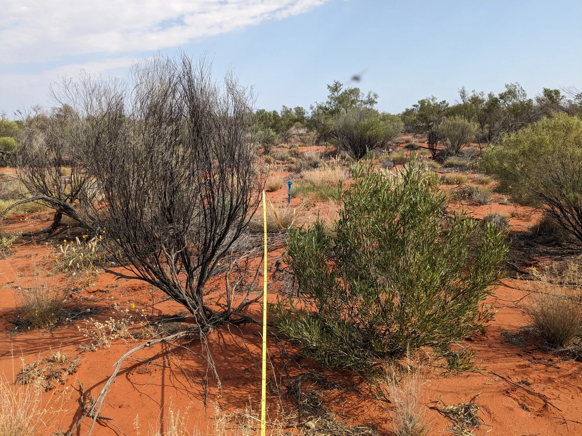
- Field survey was planned with a stratified random approach ensuring a robust sampling of spectral, spatial and vegetation characteristics across the property, within reasonable distances (between approximately 75 and 500 m) from accessible tracks and roads.
- A total of 238 random field validation plots were surveyed on-ground by expert ecologists with region specific knowledge, as well as by drones, in 30m x 30m quadrats oriented with magnetic north between September 2023 and October 2023. The drone survey used LiDAR and RGB sensors to capture crown cover, vegetation classification by height, LiDAR point cloud and RGB orthomosaics.
- The field survey and drone LiDAR data was used to understand which field sites contained regenerating tree species, and which could achieve forest cover during the project. This is based on height and number of saplings, and current and projected tree crown cover.
- Field plots were classified as being representative of Forest, CEAs, or NCE (Not Carbon Estimation areas) by incorporating all the data collected from the field including all species and stem measurements, crown cover, observations, photographs and any comments.
- The plots were then split into calibration and validation sets based on a random 70:30 split (n = 166:72).
- Aerial LiDAR data was collected – covering the full extent of the property’s boundary – between September 2023 and October 2023. A wide range of data products were created from the aerial data and then integrated into the image composite used in supervised classification and ultimately used to inform the training data for the stratification. The final classes within the initial stratification included: CEA, Forest and NCE.
- RegenCo’s initial stratification process involved the composite of two Sentinel-2 images (captured in October 2023) along with several aerial LiDAR derived data products (including tree canopy cover) to generate an initial stratification.
- Image classification was conducted using proven algorithms in remote sensing land cover and vegetation analysis and both unsupervised and supervised classifications were performed at various stages of the classification process.
- As per the requirements of the regulations, any CEA areas less than 0.2 ha were eliminated.
- Baseline forests were mapped by remote sensing analyses of Sentinel-2 and Landsat 5 imagery across the baseline period.
- Map accuracy assessment for CEA and Forest classes (based on the withheld validation field sites) demonstrated an overall accuracy of 93.9%.
- All areas that were not CEAs and were identified as project commencement forest, baseline forest and NCEs were defined as exclusion areas and removed from the project strata. CEAs were then aggregated into units of similar ecological characteristics, species and fire history.
- There are a total of 1,747 CEAs covering an approximate area of 171,176 ha.
Managing Risks
Management of Fire & Mitigation Activities
- Wildfires are a major risk to existing and regenerating vegetation for carbon sequestration. The release of sequestered carbon by unmanaged wildfires during a project’s lifespan can have serious commercial impacts on carbon farming by reducing the amount of eligible ACCUs.
- The objective of fire mitigation is to reduce the severity and risk of harmful wildfires to CEA areas and valued pastures.
- Wildfires must be accounted for in carbon accounting models (FullCAM) when claiming for ACCUs.
- Wildfire and the use of prescribed fire need to be managed as part of property management activities.
- Measures were taken to manage wildfires on the property, including the widening of fire breaks and asset protection burns, as well as increased diligence in fighting wildfires as they occur.
- By reducing widespread bushfires on the property, plant growth (and therefore cattle feed) was protected, negating the need for cattle to eat HIR species (ie, the eligible vegetation). This, in turn promoted HIR species regeneration, maintaining the permanence of regenerating forest.
RegenCo creates a permanence plan for each of our projects. Every 6-12 months, we meet with the landholder to discuss specific risk mitigation activities for the landholder to implement – for example water points, taking into account seasonal conditions, the amount of grass, fires on neighbouring properties, and the amount of firebreaks on the property.
Assessing Fire Risks
The fire risk in the rangelands of Central Australia varies through time. The seasonal risk for fires is monitored through resources such as:
- Historical fire information (Fire mapping)
- The Australasians Fire Authorities Council (AFAC) seasonal fire outlook as well as BoM’s recent climatic conditions and long range seasonal outlook
- Australian Flammability Monitoring System by Bushfires and Natural Hazards CRC
- Using remote sensing applications to assess fractional cover, ground cover %, total standing dry matter, and grass curing index’s
- On-ground monitoring from land managers
There are a range of generic as well as property-specific risks that need to be actively managed:
- Railway line corridor
- Accidental and deliberate human and mechanical ignitions from public access roads
- Fire travelling in from neighbouring stations and properties
- Spinifex or high fuel loads that interface with Carbon Estimate Areas
- Lightning strike ignition, especially in Spinifex country
- Minimal or insufficient fire breaks or fire access tracks throughout the property
- Accidental ignitions from farm machinery and infrastructure on the property
- Prescribed fire getting out of control
- Lack of station/staff capabilities to fulfil required activities
- Mining and prospectors
Fire case study
In December 2023, a fire ignited on the property, presumably from a lightning strike from a thunderstorm following extremely high temperatures and moderate winds. See the map below of where the fire occurred:
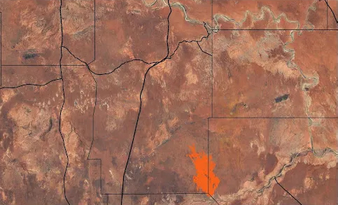
- The fire was burning in a difficult to access area in the SE of the station and spread into neighbouring stations to the east and south.
- The fire was extinguished with a combination of the landholder’s efforts and self-extinguishing with changes in fuel availability and weather conditions.
- Multiple days of firefighting jointly with the neighbouring landholders were conducted in an effort to contain its spread. Graders creating fire breaks was the main activity used.
- RegenCo visited the property to assess the severity of the fire impact. Scientific plots were selected for ground truthing and drone imaging to assess and test the severity rating.
Fire impact on the HIR carbon project:
- The fire affected an area of approximately 9,350ha’s on the HIR project area.
- The assessment on the area burnt showed minimal survivorship of regenerating tree species therefore the CEAs affected would not generate ACCUs. This paused status remained until new regeneration occurred and surpassed the carbon stock prior to fire.
Stakeholders
| Pastoral Lease holder | Central Australian Pastoralists |
| Mortgagee | The project required Bank consent and it was obtained in July 2023 |
| Crown | The project required Crown consent and it was obtained in July 2024 |
| Native Title | The project did not require Native Title Consent, as no Determination is held |
Metrics
All ACCU Scheme Project Proponents must report on their projects at regular intervals. Reports need to be accompanied by an audit report, verifying that the abatement achieved and reported on is accurate. As the project proponent for the NT Cattle Conservation HIR Project #02142022 IDR, RegenCo must provide information to the auditor to ensure compliance with the relevant assurance standards and legislation.
| Key Project Details | |
|---|---|
| ERF Project Ref No. | ERF173343 |
| Registration Date | 14 December 2022 |
| First Issuance | 10 January 2025 |
| Project Area | 466,035 ha. |
| Eligible Area | 171,176 ha. |
| Estimated Forest Cover Assessment Date | Earliest date: 7 CEAs in 2033 |
| Baseline Period | 15 February 2012 – 15 February 2022 |
| Modelling Commencement Date | 1 December 2015 |
| Permanence Period | 25 years |
| Next Regen Check | 2028 |
The reporting period in the first Offsets Report is from 14 December 2022 to 31 July 2024. Based on the initial calculations performed by the Project Proponent in accordance with the Methodology Determination, the Project has reported a net abatement of 176,728.82 t CO2-e for the reporting period.
| Total Number of CEAs | 1,714 |
| Modelling Approach | Full Carbon Abatement Model Software (FullCAM) is a government calculation tool for modelling abatement in land-based carbon projects, such as HIR. It uses a wide range of spatially referenced data and users can determine estimates of carbon stock changes and greenhouse gas emissions at fine spatial and temporal scales for ACCU projects. |
| Dates | |
|---|---|
| Model start date | 1 December 2015 |
| End date for the crediting period | 31st July 2024 |
| Project declaration date | 14 December 2022 |
| Permanence period start date | 10th January 2025 |
| Forest cover assessment date | Earliest date: 7 CEAs in 2033 |
| Audit | |
|---|---|
| Auditor | RSM |
| Audit date | September 2024 |
| Next audit date | 2027 |
Monitoring & Management
Ongoing Monitoring & Management Post-issuance
In partnership with the landholders, RegenCo develops a Grazing management plan which focuses on the development of the station’s HIR carbon project in conjunction with their cattle business. However, the management of a station is dynamic. Work on the station continues, even after the project starts issuing credits.
There are many activities carried out in the period between field surveys and the 5-year regeneration checks which are required by the CER. To ensure the project keeps regenerating, storing and sequestering carbon, an annual work program (Activity Plan) captures the Management & Permanence activities undertaken on the property, factoring in seasonal conditions, vegetation response to the management interventions and the stage of development of the business. This Activity Plan is revised 6 to 12 monthly, recording the eligible project activities that have contributed to HIR species regeneration. In addition, RegenCo makes at least one site visit each year.
RegenCo utilises ongoing monitoring and management so that the cattle business and tree regeneration can occur harmoniously. For example, by assessing the seasonal conditions, an estimate of feed available to cattle and the number of cattle at each water point, some water points may be rested or numbers reduced to ensure regeneration continues.
We use remote sensing tools like the Northern Australian fire indicator (NAFI) and Fire Watch, where we are able to monitor current fires and historical fire scars in real-time.
These activities form part of the ongoing monitoring and management of a project once it has been conditionally registered as a project with the Clean Energy Regulator.
How RegenCo market credits
To close the loop on the project, RegenCo manages the process of turning the project’s carbon credits into revenue from carbon credit sales.
RegenCo engages with landholders to develop a strategy for ongoing carbon credit sales with consideration of price risk management.
A carbon offtake agreement is a contractual arrangement between a project proponent and a buyer. It details a specified volume of carbon credits the buyer agrees to purchase over a set period of time, and the commercial terms of the transaction. RegenCo manages the sale of ACCUs on behalf of the project.
Buyers can secure a consistent supply of high-quality credits from a project of choice, and manage their exposure to price risk. Project developers like RegenCo can also secure revenue, which helps in financing, managing and scaling our projects.
As a Corporate Authorised Representative of an AFSL, we work with landholders on a prudent risk management strategy to ensure the viability of the project over its 25 year life.
RegenCo has relationships with a variety of off-takers in compliance and voluntary markets. We go through a rigorous vetting process to ensure that buyers of these credits are bona-fide, and are also taking steps to decarbonise their own businesses and operations.
The market is largely voluntary, with businesses making commitments based on ESG and ‘net zero’ targets that deliver benefits to the planet and their brand, though some of Australia’s larger emitters are required to offset emissions through the scheme’s Safeguard Mechanism.
The link below will take you to the CORE Markets website.
Explore your Carbon
Opportunity with RegenCo
Oops! We could not locate your form.